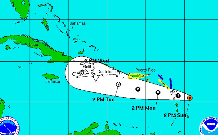
Danny to lash Leeward Islands tonight and Monday morning

At 800 pm the centre of Tropical Storm Danny was located near latitude 15.5 North, longitude 59.3 West, the National Hurricane Centre of Miami, Florida has reported.
The NHC said Danny is moving toward the west near 15 mph (24 km/h), and a westward to west-northwestward motion is expected over the next 48 hours.
On the forecast track, the centre will move near or over the southern Leeward Islands late tonight or early Monday, and into the northeastern Caribbean Sea on Monday.
Maximum sustained winds are near 40 mph (65 km/h) with higher gusts. Weakening is expected during the next 48 hours, and Danny is expected to become a tropical depression tonight or Monday.
Tropical storm force winds extend outward up to 60 miles (95 km) from the centre.
The latest minimum central pressure reported by an Air Force Reserve Hurricane Hunter aircraft is 1008 mb (29.77 inches).
Tropical storm conditions are expected within portions of the warning area overnight and early Monday. Tropical storm conditions are possible elsewhere over the Leeward Islands from Guadeloupe northward overnight.
Danny is expected to produce 2 to 4 inches of rain over the Leeward Islands, the U.S. and British Virgin Islands, and Puerto Rico through Tuesday.
A Tropical Storm Warning is in effect for Antigua, Barbuda, Montserrat, St. Kitts and Nevis,
A Tropical Storm Watch is in effect for Saba and St. Eustatius, St. Maarten, Puerto Rico, Vieques, Culebra and the U.S. Virgin Islands.


